


Muzaffarabad, the capital of Azad Jammu and Kashmir (PaJK), has long stood at the intersection of Kashmir’s ancient trade routes and strategic travel corridors. While today it is known for its scenic beauty and political importance, its historic role as a key trade hub and river crossing point often goes unnoticed.
From ancient times to the British colonial period, Muzaffarabad’s geography and proximity to the Jhelum River made it a critical gateway between the subcontinent and Kashmir Valley. his city was once a bustling corridor where caravans, merchants, and armies passed through, carrying goods, cultures, and ideas across natural and political frontiers.
Ancient Trade Routes Through Muzaffarabad and Their Importance in Kashmir History
The network of trade routes passing through Muzaffarabad included paths such as Pakhli–Dhamtor–Pattan–Rarah–Chikar–Uri–Srinagar, linking the western Himalayan belt to Kashmir’s heartland. These routes served as economic lifelines for communities in and around Muzaffarabad, facilitating trade, cultural exchange, and military movements.

Help us expose the truth
The Azadi Times is funded by readers like you. No corporate sponsors. No government influence. Just fearless reporting.
Read Also: Temples of Jammu and Kashmir: A Journey Through Sacred History & Hidden Heritage
One of the most challenging aspects of these trade routes was crossing the Jhelum River at Pattan Ghat near Muzaffarabad. Local communities used traditional methods like inflated animal-skin rafts to ferry goods and people safely across the river, demonstrating the ingenuity and resilience of Kashmir’s inhabitants.
The Jhelum River: Muzaffarabad’s Lifeline and Natural Barrier
The Jhelum River has always played a dual role in the geography and economy of Muzaffarabad and greater Kashmir. While it provided fertile lands and routes for trade, it also posed a significant barrier. Early crossings were fraught with danger due to the river’s swift current and deep waters. However, the arrival of British colonial administration marked a turning point in infrastructure development along the river and the surrounding areas.
British-Era Road Construction and Its Impact on Muzaffarabad’s History
By 1859, the British government prioritized linking the plains of Punjab to the Kashmir Valley to improve trade and military logistics. The construction of the Rawalpindi–Srinagar road, passing through Muzaffarabad, began in earnest. Between 1860 and 1870, roads connecting Rawalpindi to Murree and onwards to Kohala—near Muzaffarabad—were built, culminating in the completion of the iconic Kohala Bridge in 1871.
This bridge was a landmark engineering achievement, vastly improving the safety and speed of travel across the Jhelum River. It not only facilitated commerce but also enhanced military mobility, underscoring Muzaffarabad’s growing strategic importance.
Road Expansion: Connecting Kohala, Domel, and Srinagar
The British extended the road from Kohala to Domel and onward to Srinagar, covering a distance of approximately 126 kilometers. A British construction firm was contracted to complete this ambitious project in just two years—a feat that transformed the regional economy and infrastructure.

Read Also: Kashmiri Calendar: History, Evolution, and Cultural Significance
This expanded road network enabled the regular passage of carts, pack animals, travelers, and military convoys, increasing connectivity for Muzaffarabad and Kashmir as a whole. The enhanced accessibility helped Muzaffarabad evolve from a mere transit point to an essential hub of trade and communication.
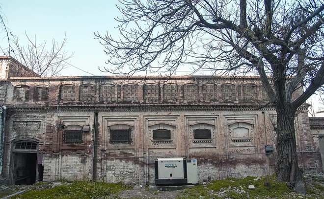
Customs House in Muzaffarabad: A Historical Trade Regulation Center
Another key aspect of Muzaffarabad’s historical role in Kashmir’s trade was the establishment of a customs house by the princely state of Jammu and Kashmir. This customs checkpoint served to regulate goods entering and leaving the valley.
All commercial goods passing through Muzaffarabad were required to stop at this customs house for inspection, weighing, and taxation. Traders were issued a transit receipt upon payment of duties, allowing their merchandise to legally move onward. This system helped the state maintain revenue and control over the flow of commerce in and out of Kashmir.
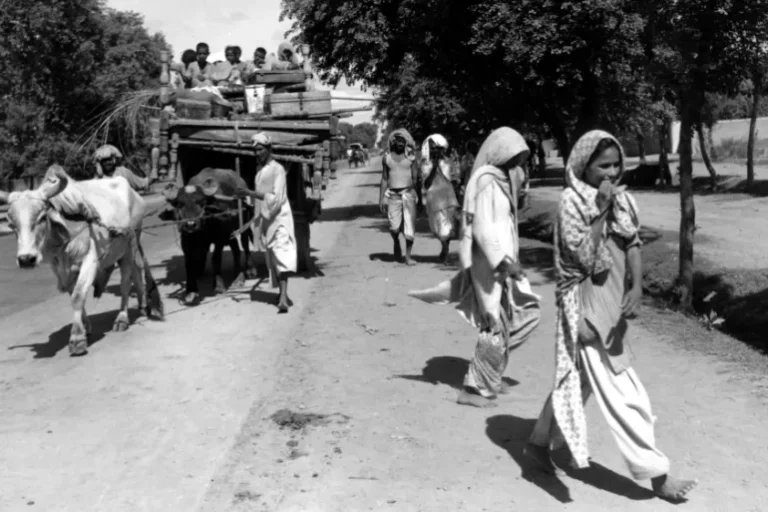
A Rare 1937 Photograph: Visualizing Muzaffarabad’s Historic Trade Scene
A rare historical photograph dating back to 1937 vividly captures the operations at Muzaffarabad’s customs checkpoint and weighing station, locally known as the Kanta House. This image provides a unique glimpse into the bustling trade activities and the regulatory mechanisms in place before the partition of India.
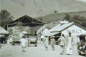
The photograph is an invaluable record of Kashmir’s pre-modern economic landscape, highlighting Muzaffarabad’s pivotal role as a trade gateway and a node within larger commercial networks.
Legacy and Continued Relevance of Muzaffarabad’s Historical Trade Routes
Today, despite political changes and evolving economic conditions, the legacy of Muzaffarabad’s historic trade routes and infrastructure remains visible. The Rawalpindi–Srinagar road, Kohala Bridge, and remnants of the customs infrastructure continue to symbolize the city’s important position in Kashmir’s history.
These sites not only serve as reminders of Muzaffarabad’s past but also offer potential for heritage tourism and educational projects. Understanding this rich history helps frame the region’s contemporary cultural identity and economic prospects.
Written & Researched by:
Jawad Khurshid Kayani
Sheher Khas, District Muzaffarabad – Azad Jammu & Kashmir
